Earthcaches

I am a proud

Sunday, February 28, 2010

Uwharrie National Forest Caching, Central North Carolina


While my wife visited with family in Wadesboro I made the 45-minute drive north into the Uwharrie National Forest on a beautiful, sunny Indian summer fall day. The circuit I drove took me to the National Forest, then to Albemarle and on to Oakville and back to Wadesboro. I avoided the micros when I got to Uwharrie. Why look for them until all the ammo boxes and lock n locks are gone. It was fun hiking the trails. I was a little concerned that I wasn't dressed in orange since hunters were starting to head out into the woods. Even though these trails are supposed to be protected I was still a little uncomfortable. I found some nice caches among the rocks and trees of Uwharrie. Lake Tillery was beautiful today. In Albemarle I stopped at Rock Creek park which runs along a creek and swamp area. I hiked about a quarter mile out a straight and paved vehicle trail to find Gabby Rocks (GC1FTH9). There was nothing spectacular about the cache itself but its what happened while I was out there. Here is a copy of my log:

This was my most exciting cache of the day. It was an easy find. Just as I put the cache back and checked my coordinates for the next cache I heard wood crack. Then I heard some large limbs falling. Then I heard a bigger cracking sound and saw a smaller rotted out tree fall against what turned out to be a larger rotted out tree. I took off running north on the trail as the big one started falling. I was concerned about the domino effect. I could have stayed put and been ok by 50 feet or so I estimate. I didn't go back. This is the first time a tree has fallen near me in the forest. It was a big one too. Thanks for the caching experience and the find.

I traveled south to Oakville, picking up caches along the way. There was one at the old train station in Oakville that is worth the stop. Nearby their was a park with several ammo cans in the park. As I traveled across northern Anson County I recalled the genealogy research I've done in this county and what I've learned about my wife's Revolutionary War and Civil War era ancestors. I had a great day today!


Sunday, February 21, 2010

Discovering a moving TB

Wow! Our friends have really taken to geocaching. I love it! Just before returning to Ecuador to take up our work again, we had a great visit with some good friends we introduced to geocaching in July. After a great meal they told us that for Christmas one spouse had given the other a travel bug tag. This one is kind of different. The tag is magnetic and stuck on the back of a small convertible that frequents the rural roads around Greensboro and Pleasant Garden, NC. This TB has a tendency to spend hours parked in front of the Starbucks at the junction of South Elm/Eugene Street and Interstate 85 near Robin's Roost (GC1ZFV7). Check this geocache out when you get the chance. You might get the opportunity to discover Travel Bug My Sanity too.

Sunday, February 14, 2010

Lake Townsend Trails, Greensboro, NC


The day started early. After some pretty rainy days we'd had one day for the ground to dry and I was ready to hit the trails. Lake Townsend, part of the watershed area for Greensboro, NC made the perfect place to get the chance to see what colder weather was doing to the woods around us. I had found most of the caches on the western-most part of Laurel Bluff Trail but need to finish the rest and then come back east along the north side of the lake. This time I went solo as Paula had things to do. She can only stand one good trail hike every week or two and she's done. I'm thankful she is understanding of me and supports my geocaching. I hiked out the trail about 2 miles before arriving at the point where I'd left off previously. It was right along the final approach for Air Harbor, a civilian airfield for small planes on the north side of Greensboro. Just off the run way to the north is the basin of the western-most part of Lake Townsend. When the floodgates of Lake Brandt are closed this area dries up to a small river instead of the lake-sized reservoir that it can be. One of the photos below shows that the water was pretty low in the morning as I started out. I made my way westward along the trail and found a number of regular size caches in the woods. I also ran into two groups of senior citizens hiking the trail. I was impressed as this is almost 4 miles between trail heads on the principle roads. One cache, Just another Box in the Woods (GC11Q8X) had not been found for eight months. There was one attempt a few months previously. It felt good to find this well-hidden, well-cammo'ed ammo box. It was kind of like reactivating the cache after so long. You can see a photo of the cache away from its hiding place above. I made it to the western most end of the trail, crossed the highway bridge to the north side and off I went to the east, working my way from cache to cache to get back to my car and completing a circuit of about 7 miles. The road that got me to the north side is right beside the dam that holds back Lake Brandt. With the recent rains it was time to open the floodgates and allow some of the water to run east into Lake Townsend. As I worked my way east the lake system was to my right. What had been swamp land was rapidly beginning to flood again. Thankfully all the caches are placed on higher ground and there is little impact on the trail. The circuit took me about 7 hours to complete, including time spent searching for caches. I'm soon going to exhaust the hiking trails around here with geocaches. These are the best. I'll take a trail through the woods and large geocaches over urban micros any and every day that I can. I recommend these trails for any of you geocachers who love the outdoors.


Sunday, February 7, 2010

Wadesboro, NC Historic Churches Multi


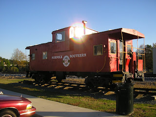
While on a five-day trip through NC to speak in churches in order to promote mission giving we had the chance to stop off for a few days in Wadesboro, NC. My wife's aunt lives here so we always have a place to stay and family to spend time with in Anson County. I had found most of the caches in Wadesboro and surroundings so one day I went to Cheraw, SC to look for a few. Another day I went to the Uwharrie Forrest to find some geocaches along some great hiking trails. I also spent a few hours one morning doing some multi-caches in Wadesboro. The first one was Wadesboro Central High School Plus (GC17687). It was a two-stage cache with the actual hidden cache in the Anson County Historical Society's property. I enjoyed seeing the old buildings that have been relocated to this site for preservation and show. The second multi-cache was Downtown Churches in Uptown Wadesboro (GCN6MR). This one required that I find a numeric clue from a date on a building or a sign, enter that into the formula to come up with the coordinates for the next stage and so on. In the course of the hunt it brought me to the local Baptist, Presbyterian, Roman Catholic Episcopalian and finally Methodist Church. The actual cache was hidden in a place for meditation at the Methodist Church. It was nice to read a little about the history of Wadesboro's churches. I also took a trip over to the next county to the east to find a few caches. Hamlett was a small town with a couple of caches in a park near the caboose pictured above. It also had a cache commemorating The Hamlet Train Wreck (GCRN1J). This was a nice ammo box hidden near the actual site of the 1911 train wreck. Hamlet was a pretty sleepy town this misty rainy day but in at the time of the wreck I'm sure it was pretty busy.