Earthcaches

I am a proud

Sunday, March 29, 2009

Podcacher

"When I'm not caching I'm listening to Podcacher." Every week, usually on Monday morning, me and a whole lot of geocachers around the world download and listen to our geocaching staple, a podcast all about geocaching from Sonny and Sandy from San Diego, California. Every week Sonny and Sandy produce a great show with an interview or topic of interest along with updates on GPSr and GPS-related equipment and software, stories of First Finds, milestone reports where folks tell about reaching a new level in geocache finds, and much more. It's a great way to fill the void between those geocaching opportunities. Podcacher also sports a forum that unites geocachers from around the globe in discussions of geocaching and related topics. You can always get an answer to a question on the forums. I've been blessed by making a number of geocaching acquaintances via the Podcacher forums. If you haven't found Podcacher yet, just visit iTunes podcasts and search under the topic of geocaching. You'll find it. You can also go to www.podcacher.com and listen to the program.  

Woman Listening to MP3 Player on Beach

Sunday, March 22, 2009

Mahuida Climb and Caches, Santiago, Chile


Ecuador is a cool place in every way. In particular it's a cool place because the weather stays in the spring time temperatures pretty much year round. I recently flew to Santiago, Chile and stepped into summertime. A good friend and I decided to climb one of the mountains to the east of the city. There are four caches on this mountain so we geared up with plenty of water and set off. Mahuida is a park. We traveled out to the park only to find that it was closed. Every Monday it is closed. The caching page didn't say that. We prevailed on the guard and then the manager to allow us to climb anyway. The kind manager took down our passport numbers and registered us to climb. He was very understanding when we told him I'd come from Ecuador to climb and only had that day free, the rest being occupied with a conference. We started out at 1900 feet and climbed to just shy of 5000 feet above sea level. There used to be a cache on the summit of the mountain but the last several attempts have been DNFs so we decided not to go for it. The first cache (Parque Mahuida GC1MBJY) required a strenuous hike on a step grade. As we climbed we got a continously better view of the sprawling city of Santiago. We could see Manquehue Mountain to our north, one we climbed and cached last year. The day was clear with very little smog so we had a panorama of the whole valley and the city. This time of year is dry so the bushes were very brittle. These were some great caches hidden in some out-of-the-way places. The challenge was not finding the cache but the climb to get there. Each cache was located right where the cache page said it was and none were needles in a haystack type caches. I honestly prefer these to the cache hidden among a thousand rocks or seashells. After reaching the second (Mahuida III GCKZFN) cache we cut across two draws with steep embankments. That took us several hours but brought us to the third cache 
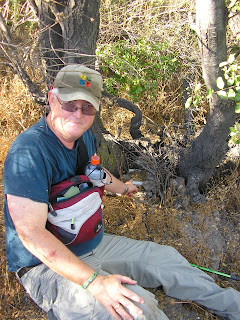
(Mahuida 2, GCJX45), hidden in a small cave. By this time the sun was beating down on us and it was hot. The cave was a cool place to rest for a while. From here it was down hill to the last cache, (Parque Mahuida GCJTAZ). This one proved to be the hardest to fine. From here we started down the trail to find our car. We made it to the entrance to the park and the ice cold water fosset! This was another great day of climbing and caching! If you are ever in Santiago on a Tuesday through Sunday, you might want to give this mountain a try. There is a small fee to get in the park.

Sunday, March 15, 2009

Chilean Summertime Geocaching


I was in Santiago recently for a community development conference recently. Since it is summertime, the days are long. We finished up everyday around 5 pm, went for an early supper and then I was free to go looking for geocaches. I kept to the urban micros since getting up on the mountain takes a lot longer. Most days I was on my own. Santiago has a great subway system. I was able to take off on my first afternoon looking for a new micro in southern Santiago. After walking a mile from the subway stop I found the small park too crowded with muggles to get the cache. I had to abandon the effort for another day. On the next day I was able to walk from the restaurant where the rest of the gang was enjoying a leisurely meal. A mile away was a new micro hidden in the rocks in the park. Parque Cuauhtomec (GC1MBJY) was a fun cache. See the photo of the 35mm laid out. The next day, my last in Santiago, my good friend Garry drove me around. We found several new micros scattered around the city.  One was the cache that muggles kept me from two days earlier. I really appreicate the growing geocaching community in Chile. 

Saturday, March 7, 2009

Climbing and hiding a cache on Volcano Illaniza Norte, Ecuador


What a spectacular view we had from Illaniza Norte! It all started with a two hour drive south out of Quito along the Pan-American Highway to just south of Machachi. From there we took the cobble stone road through the town of El Chaupi for about an hour out through fields and dairy farms. Looming before us was the remnants of a once majestic and large volcano. Today only two peaks remain of what must have been a huge explosion. The southern peak is a beautiful cone-shaped peak. The northern peak is slightly lower in elevation and not cone-shaped. The southern peak requires a technical climb, then northern does not. We set out from the parking area known as “The Little Virgin” from which we would begin our 3.5 hour climb to the refuge building. Before starting the climb I hid a new geocache entitled, Illaniza, La Virgencita GC1N83W The hike up passed through three types of terrain. The first third of the hike was along an old washed out road. Heavy rains had carved large gullies big enough to swallow a large truck. The landscape was covered with shrub brush and a scattering of Quenual trees. I found the hike to be rather demanding. We were each carrying 30 lbs packs up the mountain. Although we knew of a refuge there, we had read a blog indicating that it is often unattended, with no gas to heat, food or water. This meant that we had to pack in all our water, food and sleeping bags. The next segment of the hike was along a long ridgeline running southwest. From the trail we watched two condors cruise the sky looking for prey. I was pretty tired and not sure that I wasn’t the prey they were looking for. The last segment of the climb was the toughest. The ridge trail dropped us off at the base of a steep grade made of volcanic rock and sand. It was very hard climbing. It was a joy to finally see the dull yellow refuge building in the distance. The refuge was pretty basic. There were two bunk beds with mattresses. There was a kitchen but no working stove for cooking or heating. We claimed our bunks just in time as a group of seven Ecuadorian university students arrived just behind us. The ten of us would share the refuge that night. The sun warmed us for the next two hours but when it began to set, the cold set in. We ate our small supper before the dark set in and were in bed at 7 p.m. thankful for the warmth of our sleeping bags. The night was not the most restful night due to the antics of our university friends and the headache brought on by a combination of altitude (15,500 feet above sea level) and dehydration. At 3:30 a.m. we were up and preparing for our climb. After a light breakfast we set out in the dark with our headlights guiding us up the trail ascending the northern peak. In the distance to the north we could see the reflection of the lights of Quito of the clouds. To the north we could see the occasional flicker of headlights on the university students as they worked their way up the southern peak. About an hour into the climb the sun began to push its light up on the horizon. There in the foreground, with a sea of clouds around it, stood Cotopaxi volcano in all its majesty. With every step and every moment that past the sunlight cast on the northern peak of Illaniza made it more spectacular. About two hours into the climb we arrived at a rock bridge with a precipice on each side. The bridge was a foot or two wide at most places. Now I’m a grandfather and I began to have some second thoughts about going further. Brett and Jeremy walked right across it and assured me that it wasn’t as bad as it looked. I told them to go on from there and I’d wait for their return. From where I sat I could see a glacier lake to the west, Antisana Volcano, Ruminahui  and Cotopaxi volcanoes to the east. As I sat in the sun and listened to the low wind I could also hear my friends conversation as they climbed further, even though they were out of sight much of the time. Then I saw them appear on another ridge about 200 feet above me. They were the distance of a football field away and their words were clearly discernable. When Jeremy said, “I’m done” I knew that I wouldn’t be sitting there alone much longer. They had reached a point where the climb really was becoming technical, requiring climbing gear. They worked their way back to my resting spot. They had reached 16,400 feet above sea level, just 400 feet short of the summit. We were back at the refuge at 8 a.m., repacked and soon on the trail headed down. This time we met up with a red fox who has obviously become accustomed to climbers and the scraps they leave. He seemed headed for the refuge. The hike down the mountain took a couple of hours. We departed the mountain as a different condor looped above us. If you get the opportunity to visit Ecuador, this climb is worth your time. Enjoy not only the geocache hidden at the base of the mountain; enjoy the beauty of the Andes mountains at their best! 

Sunday, March 1, 2009

Travel Bugs


Goecaching has several twists to it. The basic sport involves the search, find and logging of a geocache. Now mix in registered and tagged items that have as their goal to travel from cache to cache on a journey wherever the owner pleases. That's right. This "twist" depends on the faithfulness and honesty of geocachers to responsibly move these tagged items along their way. Sometimes the goal is to travel to all 50 US states; to travel from one place to a specific cache somewhere, or simply to travel the world indefinitely. Currently there is a race going on between a number of geocachers. They each launched a TB with the goal that they make their rounds and return by a given date. The cache that travels the greatest distance wins. How do you know the distance a TB travels you ask. Each TB has its own page on the www.geocaching.com website. Everytime one of us moves a cache we log in to the TB's page and indicate that we have possession of the TB. When we drop it in another cache we return to the page and indicate where we dropped it. Travel bugs can be just about anything you think of and can put a tag on. The owner of the TB gets an email message everytime it sees activity. Anyone can go to the TB web page and see the log entries and even see a map of its journey. Every geocacher that logs finding and moving the geocache sees his or her TB count go up. Even those who simply note the tracking code and leave the TB where they found it get credit for having "discovered" it. There are some really interesting TBs out there. Now for the sad side of the story. Many TBs live a long life and make their intended journey. Unfortunately many go missing on the trail. Whether found by muggles, the uninitiated to geocaching who stumble upon the cache and find the TBs inside, or by careless or uncaring geocachers who misplace or keep it; the TB disappears. Even with the potential that you will lose your TB, those who launch them add a new and gratifying demension to the sport. In other words, TBs are cool!