Geocacher
low_rider73 shares about hiking the Inca Trail:
In December 2011, my brother-in-law came to Peru to visit us. He and I have talked for years about hiking the Inca Trail together. Although December isn't the best time to hike the trail for the rain, we also knew that it would be less crowded due to it being the "off-season".
Once he arrived in Peru, we headed up to our house in Huaraz and started preparing for the hike. We did several hikes in the Huaraz area and ran several times to prepare for the 4 day journey that we were about to embark upon. We knew that one of the greatest challenges of the Inca Trail is the altitude. Therefore, several of our hikes outside of Huaraz took us to higher elevations than what we would see on the Inca Trail. After the preparation, we set out on our journey.
First, we drove to Lima and boarded a flight to Cuzco. Most travel guides recommend that visitors spend at least a day or two in Cuzco to acclimatize to the altitude, but we knew that we were already acclimatized, and so we arrived in Cuzco in the afternoon and planned to leave bright and early the next morning. While in Cuzco, we had to meet with the guide that was going to lead us through the trail, and so we did that, visited the Plaza, and got a bite to eat before getting some rest before the big day ahead of us.

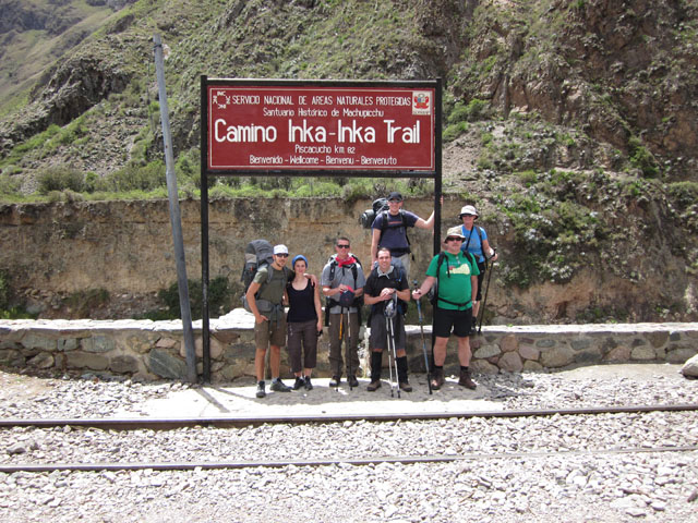
On the first day, we left Cuzco and headed off in a van to the trail head at kilometer 82. From there, we set off on foot to begin our adventure. Unfortunately, the entrance to the trail is extremely unorganized, and so we waited for a while before it was our turn to pass through the gate and cross the bridge over the Urubamba River. The first day is classified as "easy" and as a day of acclimating to the altitude. We found that day one was described correctly and we were surprised at how quickly the time passed. We stayed together as a group and hiked at a slow, but comfortable pace for the first day. We only hiked 12km the first day.
We hiked with a group of 7 "tourist" and our guide. We also had 7 porters (carrying all of the tents, food, cooking supplies, etc…) and a cook. Normally the cook and porters raced ahead and we would see them either at the spot to stop for lunch (where they normally had the "kitchen tent" and "dinning tent" already set up and lunch mostly prepared), or at our final destination for the day (our camping spot). The surprise for me was that the porters set up and took down everything each day. Therefore, all we had to do was to hike (carrying our packs) and make it to lunch on time or to the campsite each night. Because we weren't carrying tents, food, cooking supplies, etc…, our packs weren't that heavy. I carried my own bedding, clothes, snacks, water, etc…, but it wasn't bad at all.

Day 2 is known as the "Challenge" and it lived up to its name description too! We set out and started climbing up towards the "Abra de Warmi Wañusca" (or Dead Woman's Pass), which sits at an elevation of 4,200m (or 13,776 ft.) above sea-level. We learned quickly that the hardest challenge wasn't the climb from 3,100m (10,137 ft) to 4,200m, the challenge was that it was all stairs! It was like some mean joke that the Incas wanted to play on the rest of the world! That day we traveled around 10km, but the vast majority was either going up stairs, or going down stairs. Doing it in the rain just added to the fun! By the time we made it to the top of the pass, the rain was coming down pretty hard! Obviously, on this day, we didn't stay together as a group because some people were able to climb at quicker rates than others. Therefore, my brother-in-law and I set out and met up with the rest of the group when they made it to camp later that afternoon. Needless to say, we were all quite exhausted and ready to rest at the end of day 2!

.JPG)
Day three is known as "unforgettable" because you travel through some beautiful areas of the Andes Mountains and the high rainforest. We also saw more and more ruins the closer we got to Machu Picchu. The unfortunate thing was that the rain and clouds prevented us from seeing some of the breathtaking views that we were told about. However, the rain and clouds did make walking through the high rainforest seem more legit than if it were a clear and pretty day. This day, we covered about 17km of terrain and we tried to stay together more as a group so that our guide could tell us about the ruins that we were seeing. Typically, what would happen is that those of us who were quicker would hike on ahead and sit at the next stop to wait on the rest of the group. The cool advantage that we had was that we could listen to the other guides teaching their groups about the location and learn more about the site than just hearing about it from our guide. (Our guide was good, but each guide tells the story differently and includes or forgets certain details.) On the 3rd night, we camped at 2,700m (8,829 ft.) and enjoyed the somewhat warmer weather.
Day four was the big day. We woke up early and hit the trail quickly so that we would be some of the first to set out that day to get a glimpse of Machu Picchu from Inti Punku (or the Sun Gate) as the sun was rising. They don't allow groups to start any earlier than 5am, so we all stood in line at the entrance gate waiting for the opportunity to begin our final day of hiking and to see Machu Picchu. After the previous 3 days worth of hiking, we were all tired, but the adrenaline was enough to keep everyone moving at a good pace. When we arrived at Inti Punku, it was cloudy and we couldn't see anything. However, we sat around for a while and patiently waited until the clouds began to break and the beauty of Machu Picchu was revealed. Most people there were seeing Machu Picchu for the first time ever, and so it was a special experience for them. I had been to Machu Picchu once before (a little over a year before this trip), and so I wasn't seeing it for the first time, but it was still a spectacular site.
.JPG)
After taking pictures and such, we set out to finish our hike down to Machu Picchu and to enter the park. The unfortunate thing is that you have to walk into the site, walk down through it, and out the front gate to be "officially" allowed back in. It seems to be a very strange and inefficient way of doing things, but I guess that it works. We checked our hiking backpacks at the storage room at the gate and entered officially back into the site so that we could begin our little tour with our guide. After an hour or so, he turned us loose and we were on our own. Since I had already been there, my goal was to see something new (which ended up being an Inca bridge constructed about a 20 minute walk behind the site) and to hunt for a geocache that has been places there
(Para Emmy-n-Sapphie - GC19941). My brother-in-law was interested as well, and so he accompanied me to the bridge and then back to the main site to hunt for the cache. Unfortunately, my GPSr wasn't being on its best behavior, and so we walked around for quite a while before it finally zeroed in on the cache location. After searching around for a few minutes, my brother-in-law actually located the cache, we signed the log, and off we went. By that time, it has started raining, and so we took off to the gate to get our packs and to get on a bus down to Aguas Calientes to catch the train out. There are other caches around Machu Picchu (like an Earth cache) that I would have loved to have located as well, but when the rain started to pour, we decided that we had been wet for long enough and that it was time to get out and get a shower!
All in all, it was a great adventure and I highly recommend it! Machu Picchu is a beautiful site with lots of "mystery" and history to be enjoyed by all! By all means, if you ever visit Peru, plan to visit Machu Picchu. If you have the time and health, I would also recommend that you hike the Inca Trail. And, if you are a geocacher, be sure to bring along your GPSr because you are bound to rack up a few smiley's from your visit! (There are also come cool caches in the Cuzco area, but we weren't there long enough to look for them - I will have to hunt those down on a future trip!)

 A few week ago I told you about our flight to Cruzeiro do Sul, Brasil. We had a great time there. We spoke with some travel agents about the wisdom of promoting tourism in the region with geocaching. None had ever heard of it. Some were interested and others were not interested in the idea of geo-tourism. There are a few here thanks to GTAbusquedor so we explained how if these attracted any tourist how it would be worth it to place a series up and down the river and let tour guides take folks to find them in their boats. I hope there is a positive response. While visiting friends we took off to find the caches that have been placed in the area. With my friend we headed out to find CFL (GC3N3X7) near a training institute for church leaders. The pastor who owns the land gave local geocacher cheysol permission to place this cache. Nonetheless it was good that we stopped by to ask permission since it is on private property. He gave it and we had a good time finding the cache and visiting with him. So much so that on Sunday we returned to visit church services. My friend gave me the cache information as this cache was not published. This was my friend's first cache placement and he was disappointed that he'd been waiting for over a week for the reviewer to approve or provide some type of feedback. We went for it anyway. It was great to get out into the countryside for a while. Don't go looking for this one though! Unfortunately my friend became frustrated and archived the cache when the reviewer required he answer a bunch of unnecessary questions, some of which he had explained clearly in the cache information.




.JPG)
.JPG)


