Earthcaches

I am a proud

Sunday, September 29, 2013

Caching the Corridor, NC - SC - GA

We came back to the US almost one year ago. As missionaries we were blessed to be loaned a Chrysler Town and Country Mini-van to get around in for the last year. It has been my geocache-mobil for these months... and a good one at that. It went camping in the Uwharrie Forest and carried me up the Blue Ridge Parkway several times. The loan was for one year so just two days ago I had to return the van. Along with my son-in-law, I traveled southwest down the I-85 corridor from High Point, NC to Atlanta, GA and then a little south to Jonesboro, GA. We left early in the Welcome to South Carolina - The Palmetto State (GC3CVJH), as described on the cache page, was right out in the open. It sat in front of a window where the administration can look on. We were there before the office opened so other than the occasional traveler, we were not too obvious. After finding the cache, signing the log and heading for the car, I remembered that I needed to drop a travel bug. I returned and when I finished placing it one of the maintenance workers called out and sort of congratulated me on my find. I can't say her words as they would be a clue.
My son-in-law with the Paint the Town Red Cache
morning dark but made it to the SC Welcome Center by daybreak. There we found the first simple PnG cache.

We continued on down the road kind of racing the clock as we needed to get to the First Baptist Church of Jonesboro, GA by noon. They host one of the chapters of Macedonian Call Foundation, the group that so kindly loans missionaries vehicles for their time stateside. We were in and out with the vehicle turn-in. It literally took five minutes. It was incredibly easy. I wish all things in life were that easy. A big thanks to MCF for their assistance!!! As we climbed into my car to leave, my son-in-law and I realized that the next cache was .1 miles away. We just left the car in its parking place and headed out following the needle. It led us up to Main Street to an Art Gallery. We found CC Series 2: Paint the Town Red (GC385R7) just where it was said to be. We sat down to fill out the log sheet and to take in the view across the railroad tracks of what looked like the municipal building.

We headed back to the car and hit the road for NC. We stopped several times along the way, either for gas, geocaches, lunch or to stretch our legs. Just outside of town we picked up Lisa's Cache (GC27CT4). It was a small that gave me a chance to drop another TB. This was a shopping center
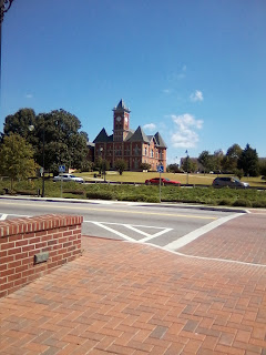
Jonesboro, GA from the Paint the Town Red cache
but off to one side where we were not too obvious.

Further up the road but still in Georgia we stopped for The Buford T.B. Hotel (GC45QRG). Most TB Hotels are closer to the road. This one ranks high on my "secure from muggles" rating because it was a good walk from the car, far out of sight of any muggles. We parked on an unused road near an upscale shopping complex. Some concrete partitions blocked me from driving further. As we crossed the barrier we found a makeshift dog house and a bowl full of water. We didn't see any animal but signs that at some time in the recent past someone was trying to feed an animal there. We tracked up an old asphalt road and into a field. We turned 90 degrees to the left and tracked down through tall grass until suddenly our feet started to get wet. We were sinking into standing water. We back tracked and found a way through the woods to the GZ. There it was! This was a nice cache! We signed the log and took a few pictures.

Wet feet got us there!
Our last cache was X-Tie Dump (GC23V40). It was along the corridor in South Carolina. This one was a quick PnG. We signed the log and hit the road. There were three hours left to get home. Other than the typical traffic jam along I-85 near Charlotte, NC, our trip went well.

My new job has kept me busy. These were the first caches I've found in about six weeks. There are lots of geocaches along the corridor. True, most of them are somewhat lame, a number being LPCs (Lamp Post Caches). Most of the ones we found were worth the stop. I sure hope I can carve out some more time in my schedule to cache!

Sunday, September 22, 2013

Banner Elk, NC -- mountain beauty and a little geocaching

Our cabin in the woods

Our view to the west!
I am now serving as the pastor of discipleship and evangelism in my home church. Last week the pastors of the church went to Valle Crucis, NC for a retreat. It was a great time for getting to know each other (since two of us are new to the staff), for praying together and for recreation. One of the members of our congregation has a log cabin on the side of a mountain with a westerly view of the sunset down a beautiful valley. Looking down the valley made by the meanderings of the Watauga River we were blessed to see such beauty every morning and, at sunset, to see the powerful colors across the sky.

I mentioned to the other pastors our little pass time called "geocaching". One thought he'd heard something about an electronic treasure hunting game but knew little else. The other two pastors gave me a quizzical look. They had nothing. So when we headed out to Banner Elk to see the sights one day, I told them we were going to find a couple of geocaches. They were all for it.

Of the course of the three-day retreat we had the opportunity to visit Banner Elk, Blowing Rock and Boone at least once. We started our sight-seeing in Valle Crucis. There isn't much "downtown" to this little community. The highlight of the place is the Mast General Store at the Back in Time (GCXRRF) is worth your time.
Thanks to SeeMidTN.com (a.k.a. Brent) for the photo of Mast
General Store in Valle Crucis
crossroads that define the center of the community. There are several other Mast General Stores, one in Boone, that I've visited. The original Mast General Store in Valle Crucis is worth the trip. It has maintained its look and feel. Started in the 1883, this store has served the community a long time. In Boone it is the name brand that attracts folks. My only problem with the Boone store is that it is more a department store than a general merchandise store. I recommend a visit to the original. Check out the geocaches nearby. In particular the multi-cache entitled

Up the road in Banner Elk we found another one entitled, Dugger's Crooked Creek (GC3FGAV). I took along my muggle pastor friends. One stayed in the car, exhibiting a low level of interest. The other two got out and helped in the search. Right away one of them came up with the cache. We signed the log and headed for the second cache, situated beside a large duck pond where we'd had lunch the day before. This one was called Just B.E. Yourself (GC1RXAM). It beat us. Our friend who was a little less than interested was driving and seemed to be in a hurry so we didn't feel we had the liberty to keep the search going as long as I would have. I hope someday to get back to this one. I love caches in mountain rhododendron.

The mountains around Boone, Banner Elk and Valle Crucis is full of geocaches. The area is a great get away from the heat this time of year. I hope you'll come visit.

Sunday, September 15, 2013

A losing streak?!?!

Intercoastal Waterway
As much as I enjoy the beach I have to admit that I was bummed out by yesterday and today's losing streak when it comes to cache-hunting. After a great day at the beach and one cache find on the way home I was all set to meet an old friend and introduce him to geocaching. We traveled from Ocean Isle to Calabash, North Carolina. There we stopped to grab a letterbox hybrid cache, then fill up with gas at a 26 cent savings in South Carolina. North Carolina has high gas tax tacked on. From there we went to a great and inexpensive seafood restaurant in North Myrtle Beach. The place is called The Shack and is located at 1128 Sea Mountain Road. The food was excellent and our meet up with our friends was great. We hadn't seen them in over 10 years. Now that they've moved to Myrtle Beach we'll have a better chance to get together with
Intercoastal Waterway, tough paddling
more frequency. After eating we headed over to Barefoot Landing, a commercial center on the water with all kinds of shopping and entertainment opportunities. We had a good time walking around and catching up. My three-year old grandson was with the family. He asked me if we could find a geocache. I mentioned it to my friend and discovered he'd actually be on a geocaching hunt once. He went with his son in New Mexico earlier this year. They went for three geocaches and came up empty-handed. I thought for sure this would be his chance to experience a find. There were two caches I'd not found in Barefoot Landing. We hit them both, searching high and low and attracting all kinds of attention during the night. No cache! My friend wonders if geocaching is for real. He's 0 - 5 on geocaching. Sadly he'll have to learn more later.

Kayaking to a lost cause
Today I had a repeat of the experience. After a day at the beach we tried for two caches on the way from Sunset Beach back to Ocean Isle. Both left me empty-handed. As soon as I got back my son-in-law had the kayak loaded and we were ready to go to the Intercoastal Waterway. We headed a few miles away to launch the kayak at Ferry Landing Park. The kayak trip was great. We paddled out in our two-man kayak, rounded the pier where some fisherman had use of the water immediately in front and we turned south along the Intercoastal Waterway. We paddled a few minutes to cover the .47 miles showing on my GPSr. As we approached the beach we traveled through about 75 yards of three-foot tall grass. Since it was high tide we paddle right through it up to the beach. The beach was completely infested with small crabs that scurried
A pretty easy cache once the coordinates were right
everywhere when I got out of the kayak. I ignored them and was grateful that my wife wasn't along. I'd have been carrying her had she seen the crabs. I tracked to a prominent tree, certainly the one where the cache owner had attached a regular size cache up in the tree above any rising water. I looked and looked. My son-in-law looked but to no avail. The cache just wasn't there. Some storm may have taken the cache. It has been about a year since it was logged. We checked the surrounding trees to make sure and found no sign of a cache. The light was fading so we headed back, this time with my headlamp as a way to warn boaters of our approach. The trip was even easier returning north. We made it back to the beach, loaded and went home...without a single cache for the day. Bummer!

Hey, there's a good side to every bad day! The next day or two work out better. I came home to look at the logs on Angel's Trace (GC444YH). I found out a clue. The next day I went back. Still no joy! Back to the log to read more. Some distance back in the logs I saw a cacher had given a better set of coordinates. Having the right coordinates makes all the difference in the world! We stopped by on day three and there it was, some 50 feet away from the posted coordinates. I logged it and also logged a maintenance needed note. Either the cache needs to be moved to the posted coordinates or the coordinates need to be updated with something more accurate. All's well that begins with geocaching!

Sunday, September 8, 2013

Secluded end of the island geocache

North end of Ocean Island looking south
Ocean view coming back out from the cache find
During a lull in our beach time while everyone was interested in staying in the air conditioning, I took off to look for a few caches on Ocean Island, NC. Several years ago while we vacationed on Emerald Isle I found a cache at the end of the island where the inlet meets the ocean. It was a fun cache so I was quick to plan a trip out to the northern end of Ocean Isle to see if the experience was just as nice. It was! I followed the directions on the cache page. I parked in the last legal parking and walked about 1/3 mile to the beach access. The inhabitants of this end of the island are struggling to stay about water. The beach-side houses are sandbagged with very large bags, much bigger than a person could lift. These had to be placed by machine. As the tide comes and goes, it exposes some beach. During high tide, the water comes up onto the large sandbags. Will these homes survive? Who knows.

A lovely place to hide a cache
As I walked out to the north of the last houses to find the prescribed beach access, I curled through a green picket fenced sandy access to the beach. Just as soon as I came out of the access way I was met by a beautiful view of the northern end of the island. The beach was gorgeous and their were only a handful of people there. I marked it down for another visit with my wife later. We've been on a crowded but nice beach for several days. The peaceful and quiet beach was a welcome change. I tracked up the beach and was almost the only one for a quarter mile. I found a jeep trail over the dune and soon found myself in the scrub land. I tracked right to the GZ and within a few moments found the cache. Back in the bush (GC213NR) was a fun cache to get to. The fun was in the hike, the scenery and the solitude.


The next day I brought my wife, one of my daughters and her husband to see this beach. We collected sea shells and enjoyed the quiet. I recommend this cache to anyone coming to this island. There are others worth your time. For me, this one beats them all.

Sunday, September 1, 2013

Macon County, Tennessee Covered Bridge Geocaches


Central Tennessee has a lot to offer. While there to speak in an association of Baptist Churches I had the opportunity to travel to some of the outlying towns. I left Livingston on my drive northwest. As I traveled I passed through some beautiful country. It took a full hour to get to the beautiful little town of Red Boiling Springs, the westernmost town I'd visit on this trip. If you take the by-pass around town you'll miss the small valley with its picturesque stream and covered bridges. I suggest you go into town to see it. As the name suggests, this was once a town that attracted tourist seeking the healing sulfur waters of the boiling springs.

It was a Sunday morning and I was dressed for church when I stopped to look for Sulfur Water Crossover (GC1X2PQ). My GPSr led me right to the bridge. The first time it took me midway on the bridge. I crossed over the Salt Lick Creek on the bridge and found myself on the lawn of the Donoho Hotel. I began searching all the obvious places on both ends of the bridge and up on the bridge. The bridge is for pedestrian traffic only, being to narrow for any motorized vehicles. I know I must have looked odd to anyone who might have been watching. After some searching I came up with the cache, signed the log and replaced it. The Donoho Hotel is one of three historic hotels built to house tourist who came to the sulfur waters during the boom years. It was built in 1916 and has been in continuous operation since then. What a nice place!

After church service I ventured back into town to try a second covered bridge cache. Bridge Over Troubled Waters (GC1X8RW) proved to be more difficult. I actually didn't get a good chance to search for it due to muggle traffic. My GPSr kept directing me off the bridge into what appeared to be someone's yard. That also caused me to take a picture and move on. Come check out the caches in the area when you can.