Earthcaches

I am a proud

Sunday, December 30, 2012

Smithfield, Virginia...Ham Capitol of the World and a nice geocaching city tour

Smithfield waterfront

One of six decorated pigs in town

The old stocks at the Old Courthouse

A chat with Ben in front of the local newspaper office

Bdramatic's pathtag
We approached Smithfield from the east. We were in Newport News so we left the peninsula via the James River Bridge and picked up some nice geocaches on the way. This town is famous for its hams. As we approached from the southeast the first thing we saw was the town's waterfront. It was full of shops. The waterfront buildings are beautiful. From there we went to Main Street to find the tourist information center. After getting oriented we headed out on our walking tour of Smithfield. Our first stop was a store/restaurant called "A Taste of Smithfield". It was fun to go through the shop that specializes in selling hams and peanuts. The samples were great there. We left with a stock of chocolate covered peanuts. We visited the Old Courthouse next. It wasn't open but the prisoner stocks out front made for a good photo. We moved on to the city museum. At the museum we saw the oldest ham, the largest ham and saw a video on the city's record breaking "World's Largest Ham Biscuit". The museum was free and worth the time. The town's tourism center has joined up with local geocachers to incorporate some caches into their walking tour. We visited and enjoyed finding Brick Walk (GC11VZ8). The historical houses that are beautifully preserved will take your breathe away. The coffee shops and bakery will draw you in just by the aroma. Of course one of our favorite caches was a simple park and grab at the tourism office. After completing the walking tour we headed out of town to the southwest. We stopped to grab Hot N Cold (GC2WJQ5). We pulled into the parking lot of the business next door. It was just a short walk across the grass to the GZ for the cache so off I went. I started my search and was coming up empty. I'm the type who feels somewhat shy about searching for a cache where I know I'm probably being watched. Usually when I find that a cache is in front of someone's workplace where they can observe you from their desk, I'll avoid it. So, with the cache eluding me I headed for the car. Just then a voice calls out, "You aren't giving up yet are you?". It was one of the co-owners of the cache and she encouraged me to give it another shot. I did and was still coming up short so she gave me a good hint. Not only did she give me a hint she brought me one of her pathtags as a reward for my tenacity. It was a pleasure meeting bdramatic! We said good-bye before hitting the road on a long trip to High Point, NC. We really enjoyed our visit to Smithfield and hope that you'll get the chance to visit too!

Sunday, December 23, 2012

The Mayan Apocalypse and Geocachers - 21 December 2012

Mayan Calendar Geocoin
Geocachers braving the cold at the Cline Observatory
For months we've been hearing all the hype about the end of the world coming on 21 December 2012. According to the news there were a number of folks who really believe that the end was really coming.  We heard about folks in Russia paying big bucks to sleep the day away in a bunker. Others spent lots of money to go to some village in France that was supposed to be one of the few places that was to survive the destruction. A few others were reported to have sold off everything and partied as thought there would be no tomorrow. The distorted version was that the Mayan calendar predicted this date as the end. In fact the Mayan calendar simply resets, starts over or cycles again on 21 December 2012. With all the hype a group of local geocachers thought it would be fun to get together the night of the 21st to take a look at the skies over the northern hemisphere at the Cline Observatory at Guilford Technical Community College. After all, if there was some kind of super special alignment of the planets wouldn't an observatory with its high powered telescope help us see it?  A local geocacher named markcase (also a science teacher at a local high school) organize the event.

About 7 p.m. sumajhuarmi and I made it to the assigned coordinates. We were some of the last ones to arrive. Having obeyed the instructions included on the cache page we were ready for the cold. We had the layers on. I in my long trench coat and Peruvian chullo (knitted tobagan). Upon arrival we signed the log for It's the End of the World! (GC41MQ9) and were quickly escorted onto the telescope platform. Prof Tom English and an assistant controlled the computer that slewed the telescope into position. We took a look at several stars, star clusters, Jupiter and four of its moons as well as our own moon. The images were spectacular. We had to wait for patches of clouds to dissipate but that just gave us an opportunity to visit more.

It was a cold and blustery night but a great time for a get-together and celebrate the fact that the world wasn't going to end this way. Remember Y2K and all the fears that generated?  Jesus himself said that only the Father knows. We need not fear the prophecies of those who regularly predict the end of the world or the second coming on a specific date. They simply don't know what they are saying.

We wrapped up this educational experience with a group photo and some cookies thanks to the thoughtfulness of sumajhuarmi. We thanked the staff of the college and markcase for organizing the even. It's great to be back in the USA and have the opportunity to get to know local geocachers through events like this. Later in the evening our youngest daughter contacted us from Mexico where she was with her boyfriend to meet his family. They had taken a balloon ride over the Aztec pyramids near Mexico City where he arranged a romantic marriage proposal. She said "yes"! Instead of the "end", 21 December 2012 is a beginning" for our family!


Sunday, December 16, 2012

12-12-12 Geocaching Events... the next one is a long way off

Souvenir
It was good!
4Freds, sumajman, chanak80 & Rickydee48

XX, Chickenlvr413, sumajhuarmi, 4Freds & checkcacher


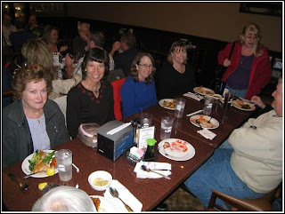
The alignment of the 12s only rolls around once in a hundred blue moons so we had to take advantage of the opportunity to get together with other geocachers. Two other factors helped influence us. First, Groundspeak was giving a souvenir for all who attended a geocaching event or found a cache on 12-12-12. Second, Nigh-Hawk selected a great place for our meeting. We went to the local China Buffet with its great selection of Chinese food.

We rolled into the parking lot ready to arrive at 12:12 pm on 12-12-12. Night-Hawk was waiting in the parking lot to welcome cachers as we arrived. One of our group, a prolific geocacher in the North Carolina piedmont region, informed us that he was to have his foot amputated on 12-13-12. What a shock as we were unaware that he was suffering from poor blood flow in his legs and that it had got to the point that he was to lose his leg. We will lift him up in prayer. He seems committed to get back to geocaching after a lengthy rehabilitation.

It was great to see faces that I saw several years ago when I attended one of these events. It was really good to see some good friends. We met up with chanak80 and chickenlvr413. We had introduced them to geocaching in 2009. We also sat with a husband and wife team that go by 4Freds. They have two children who also cache with them. It was their 20th wedding anniversary! We also met Rickydee48 and his wife. We had a great time sitting at the table as the event closed down talking about our experiences in overseas mission work. All are geocachers and members of the same church. We had a great time of fellowship and catching up over a great meal. One of our geocaching friends is check-cacher. She is standing at the end of the table in one of the photos. She is famous for her gap series of geocaches throughout the piedmont area. She works at a bank; thus her geocaching name.

As we wrapped up a number of folks headed out to find the 12 new geocaches that were activated during the morning. We have the organizer, Night-Hawk, to thank for the extra smileys. This was just the first of several geocaching events we hope to attend over the Christmas and New Year holiday!

Sunday, December 9, 2012

He died warning the settlers - John Douglass: a geocache and history in southwest Virginia

I enjoy a little history with my geocaching. On a recent trip into southwest Virginia I cached along Highway 19 between Abingdon and Lebanon, Virigina. What a fascinating area! My ancestors passed through this area while migrating down the great valley into Tennessee in the early 1770's. The events that later resulted in the establishment of the John Douglass Memorial and cache John Douglass Memorial (GC19MW3) took place just one county north of where they settled. Research shows that they too would have taken precautions against attacks. What exactly happened?

Dragging Canoe

The flat rock

Telling the story
In the days leading up to America's declaration of independence many of the Cherokee began to side with the British. One of the Cherokee leaders named Dragging Canoe rose to the forefront, leading the Cherokee in their opposition to settlers who were invading their lands in Tennessee and southwest Virginia. During 1776 and 1777 many raids were made on white settlements. These led to retaliation during which many Cherokee towns were destroyed. The conflict is known as the Second Cherokee War.  In July 1776 settlers around Fort Black (two years later the name would change to Abingdon) were warned of impending Indian attacks. The son of one of the local pioneer settlers, John Douglass, set out from Fort Black with a friend to warn the outlying settlement of Castle Woods. The two stopped while traveling northwest through the pass in the Clinch Mountain range about noon to eat. John Douglass was sitting on a large flat rock by a stream descending to the North Fork of the Holston when a shot rang out from the woods. He was shot dead. While the account told today does not say it, it is assumed that Douglass was shot by Cherokee Indians. Whether his partner continued on to warn the settlers or whether he fled back to Fort Black is unknown. Today there is a plaque on the very rock where Douglass was killed. The cache is close by too. On 22 July 1776 Dragging Canoe's warriors killed Henry Creswell outside Fort Black. During the next few weeks more Indian attacks took place in the area. Some included British Tory loyalist. It is good to see the sacrifice of John Douglass memorialized with a plaque, a wayside picnic area and a geocache.

Finding the cache: We were traveling northwest on Highway 19 and pulled off on the cut through in the median between the north and southbound lanes. It was cold and windy so sumajhuarmi stayed in the car. Since I began my Coumadin blood thinners a month ago she has been wary of my seeking any cache that could put me at danger of falling. This cache required me to cross over the guard rail and descend a few feet to where the big flat rock sits. The clue took me right to the cache. After signing the log and snapping a few pictures I was back to the car to tell her a little of the story. I couldn't wait to do a little Internet research to learn more about John Douglass. Be sure to visit this location and this cache and remember what took place here.

A special thanks to Cherokeebasketweaver for the photo of Dragging Canoe.


Sunday, December 2, 2012

The Wolf Cave: Geocaching around Abingdon, Virginia

Passing by Pilot Mountain

Abingdon Visitors Center

Wolf Cave Art

Wolf Hills

At the Wolf Cave
I love the mountains. It's just that simple. Give me some terrain relief on a map and let me go there and I'll be happy. When we were invited to come speak in Bethel Baptist Church in Lebanon, Virginia we were ready to go. Some of the prettiest country is the I-81 corridor running from the Shenandoah Valley southwest down to Knoxville, Tennessee. From our High Point home we traveled up past Pilot Mountain, through Fancy Gap over the Appalachian Mountains and south down the corridor. We picked up geocaches along the way. My favorite caches were in and around the beautiful southwest Virginia town of Abingdon. We stopped in at the Abingdon Visitors Center, a beautiful, old home from the late 1800's. It was a sunny, cold and windy day as we parked the car in the parking lot and started our search. The clue kind of through me on Thanks for Stopping By (GC2Z6G6). We looked around and finally sought shelter from the wind and cold in the visitors center. The place is beautiful. Be sure to stop in. Once warmed up and thinking we'd move on to the next cache, we went out and with sumajhuarmi's encouragement, gave it another shot. Within minutes we had the cache in hand, signed it and were back on our way. Probably my favorite cache inside the city of Abingdon is earthcache Wolf Cave (GC1X71W). It was mid-afternoon, sunny and windy when we pulled into the narrow alleyways in an older residential area of Abingdon. As we drove by the GC we realized that parking in the alleyway would block the road completely so we backed up to a vacant chiropractor's office parking lot nearby. We were only 100 ft from the GC so we walked past the muggle walking her dog. As we approached the GC we saw a piece of local art that confirmed that we were at the correct location. The cave is located underneath an old building with lattice work around the basement-like area. The lattice work affords the opportunity to see the cave entrance and gather the answers for the earthcache. Construction around the entrance leads me to believe that someone is developing the Wolf Cave for commercial tourism soon. As always with earthcaches you learn something about the formation of caves. For me the historical connection to Daniel Boone was most intriguing. Tradition has it that in 1760 while on a hunting trip Daniel Boone and his friend, Nathaniel Gist, were camping near a spring when wolves attacked their dogs during the night. They discovered that the wolves came out of a nearby cave. For this reason what became the town of Abingdon was first called Wolf Hills. By whatever name, this town was the first English-speaking settlement west of the Appalachian Mountains. There is a craft shop in the Cave House, which sits at the front of the city block on the same property as the Wolf Cave. Be sure to check it out. They have a number of wolf statues and other crafts. Abingdon is a fascinating place!  Thanks to ucumari for the photo of Pilot Mountain.